TORNADO SCIENCE & SUPER COMPUTERS - Tornado Footage compared with Simulations
Channel: Pecos Hank
Category: Education
Tags: tornado educational videohow tornadoes are formedtornado documentaryhow tornadoes starttornado informationfor studentshow tornadoes worksuper computershow tornado startsinformation videostornado information for studentsschooldr. leigh orftornado sciencetornado videosinformationtornado infotornado educationhow tornado formshow tornadoes looktornado formingpecos hankinfo
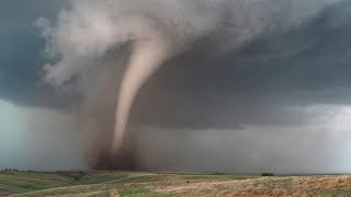
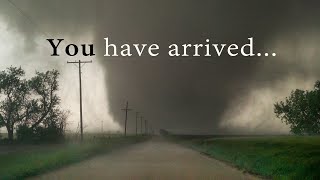
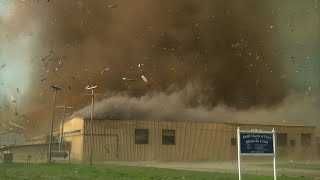
Description: Understanding tornadogenesis using the fastest computers in the world. Tornado footage compared with tornado forming computer simulations at the highest resolution possible with today's hardware. New theories and scientific collaboration with Dr. Leigh Orf. PECOS HANK T SHIRTS & MUGS pecos-hank-store.creator-spring.com The Blue Waters Super Computer at the University of Illinois is programmed with the laws of physics the best we understand them as human beings. Different atmospheric conditions can be used to initialize the cloud model. Basically you just hit go and see what happens. The model might then grow clouds that turn into storms and perhaps even tornadoes might develop. In this video we showcase the April 27, 2011 atmospheric conditions that were programmed into the model. April 27, 2011 was the super outbreak were multiple EF4 and EF5 tornadoes wreaked havoc on Alabama, Mississippi and surrounding area. Dr. Catherine Finely at the University of North Dakota found a sounding from that day near Jackson Mississippi and this was the data fed into the model. (Note* The sounding displayed in the video is the incorrect sounding) The model then grew a thunderstorm that produces a long track EF5 tornado with similar characteristics to the tornado that tore through Tuscaloosa Alabama. Because these storms exist in a supercomputer, we have access to a tremendous amount of data within and around the storm's environment. We have the ability to drop weightless tracers in different vicinities to see how they move, where they are carried AND follow the temperature, pressure, humidity and wind speeds existing within the parcel. This is an extremely powerful tool to help us understand more clearly why one supercell produces a long track EF5 tornado and why another storm does not. Ultimately, this could help us predict tornadoes more efficiently and reduce the false alarm rate of warnings issued by the National Weather Service. MY PERSONAL THOUGHTS: These cloud models still need a little work to become even more like the real atmosphere. Surface friction is not yet part of the model, and rain is not centrifuged out of tornadoes as would happen in reality. Regardless, I'm finding it increasingly difficult to have any skepticism regarding the validity of these simulations as accurate proxies to Mother Nature. For over 20 years I have specialized in observing storms and documenting them with video and stills to the best of my ability so that I can observe them again and again into the future. I find the similarities between Dr. Orf and team's simulations and Mother Nature astonishing. It's beyond incredible that a storm even develops inside a computer with updrafts and downdrafts, with vorticity, cyclonic and anticyclonic rotations, with tail clouds, mammatus, anvils, overshooting tops, horizontal vortices, a tornado with multiple vortices, helical vortices, vorticity breakdown, etc. And all of this gels with my years of observations. If the visible elements of the supercell are nailed with this much accuracy, surely the internal currents are as accurate representations. Considering all the variables, The fact that a storm grows into a tornado producing supercell instead of a burrito supreme blows my mind. Personally I feel that Dr. Orf's simulations are the most powerful tools we currently have to understand these superstorms and we need more of them. Lots more!